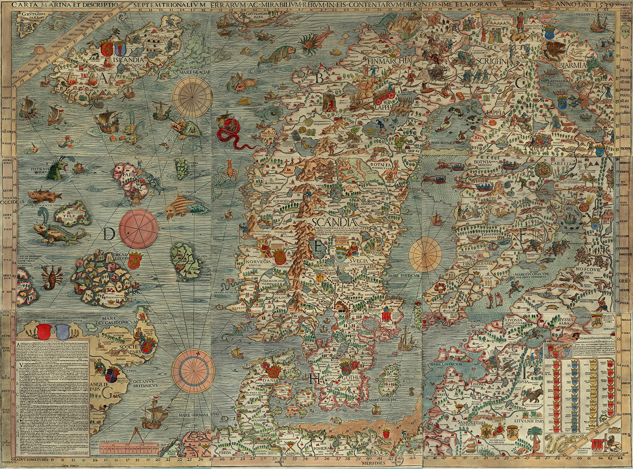
Carta Marina, by Olaus Magnus, 1539. Wikimedia Commons.
Johannes Gutenberg printed his first Bible in 1455, and the first published sailing directions appeared thirty-five years later. Print media encouraged the divergence of navigational information from material discussing the commercial prospects of trade at various ports. Printing promoted the widespread distribution of geographic and hydrographic information, including maps, to readers throughout Europe at a time when literacy was on the rise and the spreading use of vernacular languages made such works available to non-scholars.
Discovery of the sea leaned heavily on geographical and maritime information available from learned sources, including Arabic texts and rediscovered Greek texts. The Renaissance rediscovery of classical Greek learning included geographic writings of Herodotus, Aristotle, and Ptolemy, each of whom rejected the traditional view of an oceanic river flowing around a circular world. Ptolemy’s Geography, restored to Europe from Byzantium early in the fifteenth century, countered the Earth island idea with a view that oceans were entirely separated by landmasses, a model challenged by Magellan’s achievement of sailing between oceans.
Europe’s explorers actively sought and exploited both academic knowledge and geographic experience in their systematic search for new trade routes. Use of the sea ultimately rested on reliable knowledge of the ocean. Fresh appreciation for empirical evidence fueled recognition of the value of experience, and the process of exploration included mechanisms for accumulating and disseminating new geographic knowledge to form the basis for future navigation.
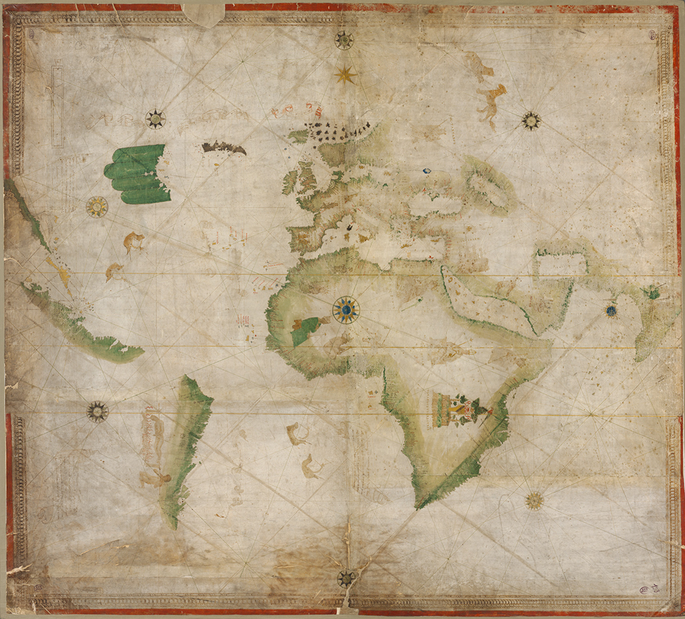
At the outset of the discovery of the seas, portolan charts recorded actual experiences at sea. These navigational aids provided mariners with compass direction and estimated the distance between coastal landmarks or harbors. Utterly novel for their time, portolans were the first charts to attempt to depict scale. Portolans created by fourteenth- and fifteenth-century explorers document Portuguese and Spanish discovery of Atlantic islands and the African coast and helped subsequent mariners retrace their steps. Accuracy of portolans was best over shorter distances, and they became less useful when navigators steered offshore.
In contrast to creators of portolans, armchair cartographers compiled world maps of little use for actual navigation but which reflected shifting knowledge of oceans. While manuscript maps had been produced alongside written manuscripts since antiquity, the earliest known printed map was included in an encyclopedia of 1470. It represents the world schematically within a circle, in which the three continents of Asia, Europe, and Africa are surrounded by an ocean river and separated from each other by horizontal and vertical rivers that form a T shape—hence the name “T-O” to describe this kind of map. Other early maps were based on Ptolemy’s work, on biblical stories or other allegories, or occasionally on portolans.
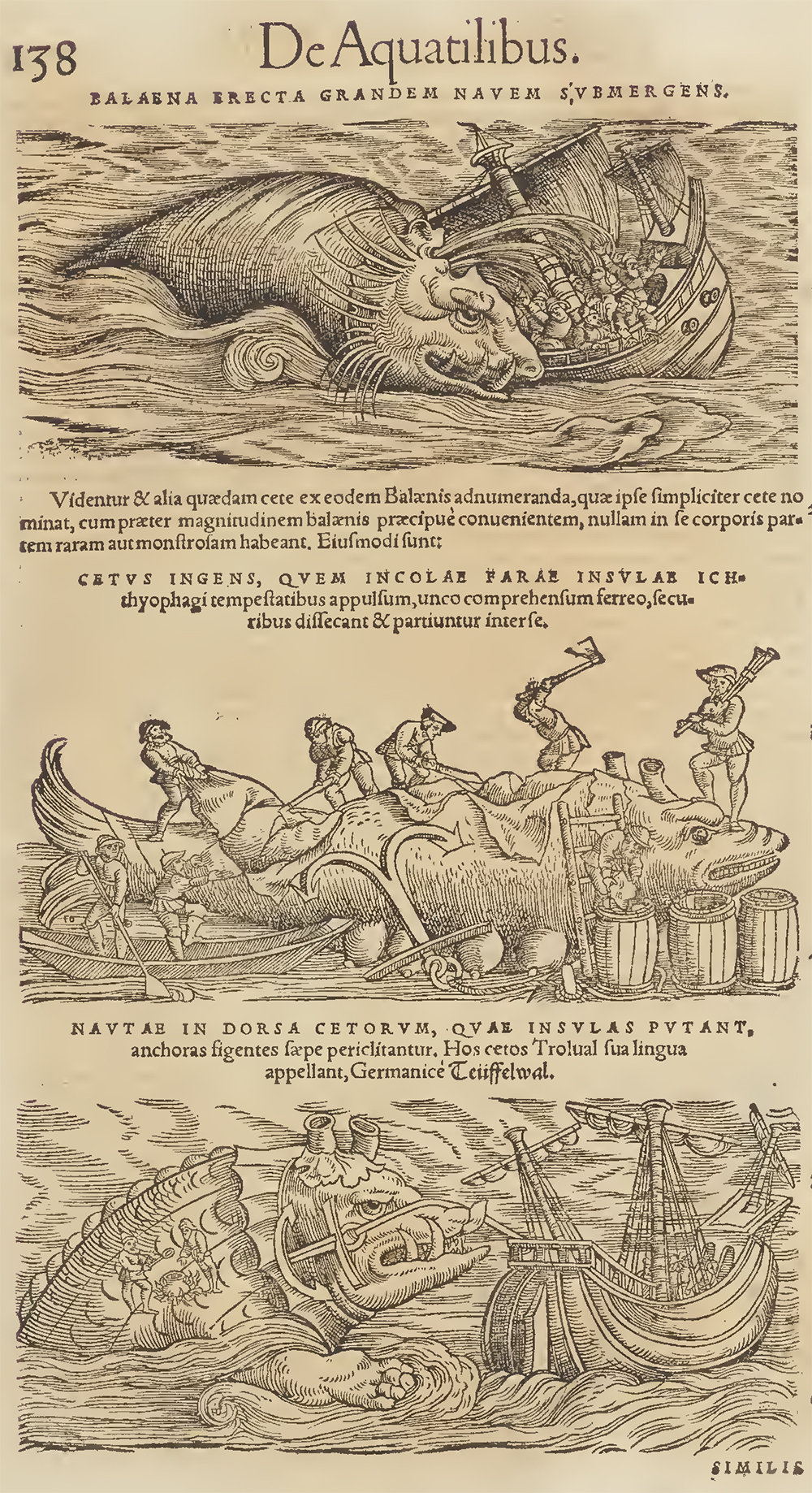
Cartographers created maps for patrons or in hopes of selling printed copies, generally seeking recent information about the ocean from a wide variety of sources, including published maps and books, manuscripts, reports from mariners and other voyagers, and, perhaps in a few cases, personal experience. Medieval bestiaries, or illustrated compendia of animals, provided models for sea monsters that appeared on maps, but Renaissance cartographers also borrowed from classical images, such as stylized dolphins from ancient Rome. Legends such as the tale from St. Brendan of running aground on an island that turned out to be the back of a whale inspired pictures on maps of mariners making fires on the backs of enormous animals mistaken for oceanic isles. Medieval maps that included sea monsters or other astonishing or exotic marine creatures often portrayed these as oceanic versions of terrestrial animals, such as sea dogs, sea pigs, or sea lions, following an ancient theory that the ocean harbored animals equivalent to those on land.
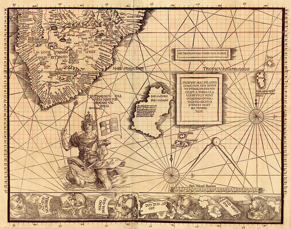
Although the majority of medieval maps and nautical charts of the Age of Discovery did not include sea monsters, the ones that do reveal both a rise of general interest in marvels and wonders and a specific concern for maritime activities that took place at sea, including in far distant oceans. The more exotic creatures are often positioned on maps at the edge of the Earth, conveying a sense of mystery and danger and perhaps discouraging voyages in those areas. Images of octopuses or other monsters attacking ships would seem to be warning of dangers to navigation. A striking depiction of King Manuel of Portugal riding a sea monster near Africa’s southern tip, from Martin Waldseemüller’s 1516 Carta Marina, displayed Portuguese mastery and political control over the sea.
The most famous representations of sea monsters in the sixteenth century frolic on the Carta Marina created by the Swedish priest Olaus Magnus and published in 1539. The map covers Scandinavia south to northern Germany, east to Finland, and including the Atlantic to the south and slightly west of Iceland. Land is represented with much detail, but so too is the ocean. There are real as well as nonexistent islands and ships carrying cargo or fishing. The sea is full of dynamic marine creatures, some recognizable as whales, sea lions, lobsters, or other species of economic value but others more fantastic or menacing. Monsters attacking ships from Protestant countries may reflect the exiled Magnus’ displeasure at reformation after Sweden broke from the Catholic Church.
In addition to his map, Magnus also wrote detailed descriptions of his sea monsters in his book, whose translated title is History of Northern Peoples (1555). While some of his marine creatures derived from bestiaries or legend, such as his account of a two-hundred-foot sea serpent living near Bergen, Norway, others of his depictions were original, and some may reflect reports of unfamiliar animals. Mariners returned home with stories of strange creatures they saw at sea, including giant whales and sharks, as well as narwhals with single helical tusks up to ten feet in length. Until explorers discovered the truth, narwhal teeth were sold in Europe and the Far East as unicorn horns. The European court knew the ocean to be the source of strange and precious objects such as coral, pearls, and mollusk shells, which began to appear in seventeenth-century cabinets of curiosities alongside dried sea horses, turtle shells, and shark’s teeth. The Swiss naturalist Conrad Gessner assembled existing knowledge about marine life in his 1558 Fisch-Buch (Fish Book), which listed about eight hundred creatures. He drew upon mariners’ tales, requested drawings and specimens from sources throughout Europe, and traveled to the Venice fish market to study for several months. Embracing the variety of living forms as proof of divine creation, Gessner’s work included both real and mythological creatures. His Historia animalium, published over the course of the 1550s, featured a unicorn among the terrestrial animals, while his sea animals included mermaids, a walrus with feet, and a number of monsters taken from Magnus’ work. Numerous other authors and cartographers similarly copied or borrowed Magnus’ influential images.
The detail captured and information conveyed in the ocean spaces of many maps testified to the extent, liveliness, and importance of maritime activity and its oceanic setting. Representations of marine creatures and other cartographic choices revealed to the viewer of a map what was normally hidden, rendering the ocean as a thoroughly three-dimensional space full of life and activity. Magnus depicted the sea’s surface as highly textured by filling all ocean space with horizontally oriented dotted lines, occasionally interrupted by wake from a moving vessel or a surfacing animal. Textured surfaces, identifiable marine creatures or exotic and forbidding monsters, and ships busily prosecuting maritime work fill map space devoted to the ocean on many cartographic works produced through the sixteenth century. The amount of such decorative detail on a map might depend on the amount of money a patron was willing to spend.
Medieval maps published in the first fifty years after the printing press often included textured oceans, represented sometimes with parallel lines and other times with broken, wavy lines. Some allegorical maps likewise featured oceans filled with lines denoting a watery surface, calling attention to what might lie beneath, while other maps that divided ocean space by latitude and longitude left oceans blank but used sea creatures and ships as decorative elements symbolizing maritime activity.
One detail on the Magnus map would seem to speak to navigators. In the area east of Iceland and extending to north of the Faroe Islands, there is a band of carefully drawn whorls, which modern oceanographers argue may represent the Iceland–Faroes front. Here, cold Arctic water currents coming around the coast of Iceland mix with warmer water from the Gulf Stream flowing north to form strong eddies that could drive a ship off course. Trade conducted between Iceland and the European continent by mariners of the Hanseatic League brought dried cod and other products from Iceland to exchange for grain, beer, wood, and textiles. Navigators certainly noticed temperature differences and also variations in surface currents, and this information was likely conveyed to Magnus during visits to northern German cities. One other map of Scandinavia from Brussels, made in the late fifteenth century, may portray this same oceanic feature also with a series of whorls. In neither map are there such curls shown anywhere else in the ocean, suggesting they were meant to represent a specific feature, one no doubt long known by Hansa navigators and Vikings before them.
Maps became more useful to navigators when cartographers created projections that could represent the spherical Earth on the flat, printed page. For open-ocean journeys, long-distance voyaging navigators turned to the Mercator projection (1569), which showed the latitude and longitude grid and corrected for the Earth’s curvature such that lines of a compass heading could be represented on the chart as straight lines or, as sailors called them, rhumb lines (loxodromes). This made it possible to keep track on the chart of a route sailed by dead reckoning. With the addition of celestial navigation, mariners could use observations of the height of stars or the Sun taken with quadrants to find their latitude and correct mistakes that arose from magnetic variation or dead reckoning navigation. Mariners would not gain the ability to find their longitude until the late eighteenth century.
Knowledge recorded on Mercator projection charts prioritized actual observations, soon to be prized by scholars associated with changes wrought by the Scientific Revolution, generally understood to begin with Nicolaus Copernicus and the publication just before his death in 1543 of his model of the universe with the Sun rather than the Earth at the center. Cartographer Gerard Mercator himself sought the newest and most trustworthy sources of information for his work, shifting from copying Magnus’ sea monsters in the terrestrial globe he created in 1541 to using recent natural history publications for his subsequent famous 1569 world map. He moved his most exotic creatures from the regions around Africa, Asia, and the Indian Ocean, where most cartographers before then had placed sirens and other dangerous or mysterious monsters, to waters off South America and the Pacific Ocean, signaling the rise of geographic interest in these relatively less traveled parts of the globe.
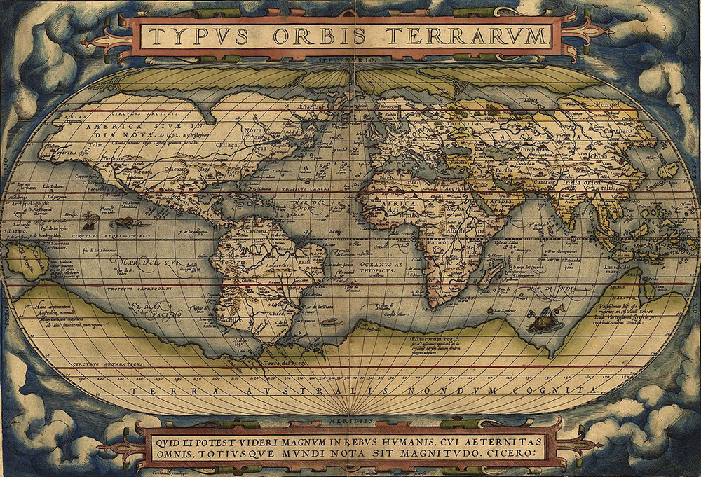
A friend and rival of Mercator, Abraham Ortelius, created a world map in 1570 that included elements by then common in visual representations of the ocean as well as some newer features. He textured the sea’s surface with stippling over all of the ocean space on his map, but he also divided that space with lines of latitude and longitude. There is one ship and two creatures that might be whales, possibly decorative elements but certainly also acknowledgment of maritime activity and a reference to the importance of whales as resources. Other maps from later in the sixteenth century feature images of lifelike whales and of people whaling, including one of the North Atlantic and what is now Canada with an inset drawing of men, possibly Basques, harpooning one whale and flensing another. This scene was copied from the first published print of Basque whale hunting at sea that had been produced a decade earlier. This map also included whale-like monsters resembling sea monsters from older sources, but the trope of sea monsters on maps and charts was fading.
In an increasingly well-known world, monsters on maps made after the sixteenth century appeared to convey fancy or whimsy rather than danger. Cartographers began to depict economically valuable marine animals realistically based on up-to-date natural history fostered by the growing experience of mariners. Actual observations of nature replaced preoccupation with marvels and wonders. Whales on charts transformed from threatening giants into swimming commodities and then disappeared entirely. The occasional decorative ship, compass rose or nautical instrument on maps gestured to human maritime activity, but banished the ocean itself. The gridded ocean space of the seventeenth century and beyond was most often left blank, without stippling or lines to denote the presence of the sea itself or to conjure the world hidden beneath its surface. Blank ocean space on maps appears to reflect a revision of the sea from a dangerous and mysterious place into a knowable part of the natural world whose control enabled the exploitation of marine resources and the expansion of European power.
Reprinted with permission from Vast Expanses: A History of the Oceans by Helen M. Rozwadowski, published by Reaktion Books Ltd. Copyright © 2018 by Helen M. Rozwadowski. All rights reserved.
